Exploring LiDAR: Revolutionising 3D Mapping and Scanning
Light Detection and Ranging also popularly referred to as LiDAR is becoming a widely used technology for many different purposes as it is quite relevant for the modern technology-focused world. This technology uses pulsated laser beams that can be used for measuring distance and hence that information can be suitably converted into a 3D map of that specific environment.
3D laser scanning is actually used in many different places nowadays for many different reasons however the general purpose is mostly for creating a map of the environment in a three-dimensional way. Some of the leading products using light detection and ranging would be wind and atmospheric monitoring LiDARs, Survey LiDARs, sensors and also other products that are required for LiDARs like PointCloud Processing Software, and Automated Guided Vehicle.
Discussing Some Major Light Detection and Ranging Solutions Used Nowadays
Wind LiDARs: As the name suggests these products are used for the purpose of measuring wind speed as well as direction and it is achieved using optical sensing techniques. These LiDARs are significantly more useful in offering huge amounts of data about wind speed at different elevations compared to anemometers. Also, these systems need not be placed at the exact location where the speed of wind and other characteristics are to be measured and hence, they can be considered as non-intrusive.
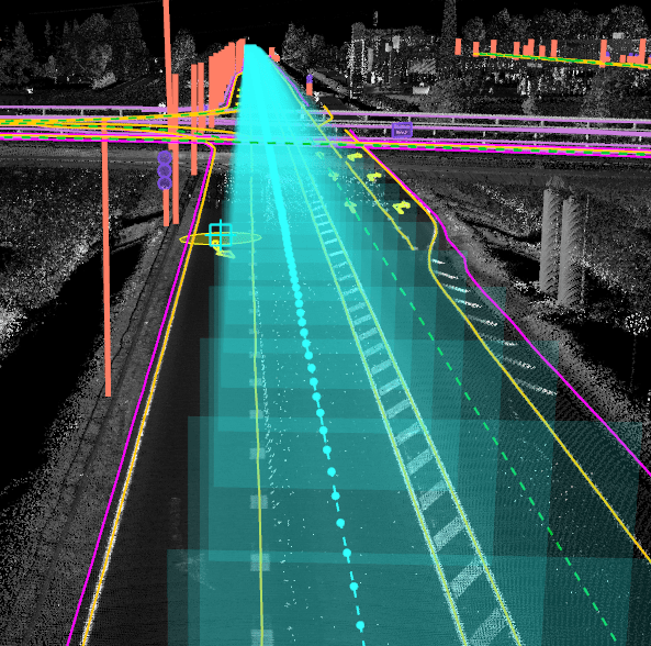
Survey LiDARs: This application has pretty good uses as it can be used to map surrounding areas and hence is essential for generating maps and incorporating crucial details like slope, critical topographical data, etc. It can be used for preparing civil engineering reports and projects, urban planning, etc and also can be used for charting out the forests, mountains, hills, etc properly.
Contact the leading companies offering LiDARs for different purposes and other services and products for utilising it in solving many real-life technological and business life issues.


Comments
Post a Comment